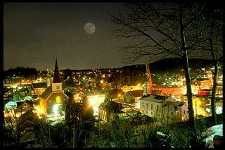
East Montpelier, Vermont, New England USA
About East Montpelier, Vermont
Washington County
Chartered: January 1, 1849 (Vermont Legislative Action)
Area: 20,475 Acres = 31.99 Square Miles [ Size Rank: 192* ]
Coordinates (Geographic Center): N 44° 16′ W 72°29′
Altitude: 727 feet ASL
Population (US Census, 2010): 2,576 [ Population Rank: 71* ]
Population Density (persons per square mile): 80.5 [ Density Rank: 53* ]
Full Census Info: Town County State
*Area, Population and Density rankings refer to East Montpelier’s relative position among Vermont’s 255 civic entities (9 cities, 242 towns, 4 gores and grants). Complete rankings are here.
East Montpelier came to be when the village of Montpelier, named permanent capital of Vermont, was set aside as a separate town in 1848, retaining the original name. Considerable bitterness existed among the townsfolk who now lived in East Montpelier: Montpelier now had the center of State government, the best waterpower sites and most of the population. East Montpelier did get most of the land, but little else. As if that weren’t bad enough, the town was now someplace else in the alphabet, along with other split-off towns which had directional words added (South Burlington, West Fairlee, West Windsor, West Rutland).
Not only did it lose the seat of government, but the railroad passed it by. Residents of both East Montpelier and neighboring Plainfield wanted the railroad, so the Montpelier & Wells River tracks were laid midway between the two towns’ principal villages in an effort to accomodate both. A station with the made name of Fairmont was established in a spot convenient to neither.
Although it was never a commercial town in any real sense of the word, East Montpelier was prosperous for a time in the 1800’s, with numerous small mills, good cattle land, and a reputation for breeding Morgan horses.
An old Native is credited with the picturesque East Montpelier place-name “Horn of the Moon“: it is what he called the place where he found his wife, who had been lost.
Activities & Points of Interest
Goings-on in and near East Montpelier
Calendar of Events provided by the Vermont Department of Tourism & Marketing.
East Montpelier Historical Society
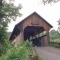
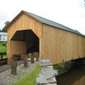
Covered Bridge (With Google Maps and satellite images):
Coburn
Click Here for a map of all bridges in Washington County.
Contact Info
Emergency Services (Statewide): 911
Hospital: Central Vermont Medical Center (Berlin) 802-229-9121
Town Clerk: Teresa Conti PO Box 157 E Montpelier, VT 05651
802-223-3313
M-Th 9-5; F 9-12
Churches, Ministries, Charitables
United Church of Christ : United Church of Christ
United Methodist : Elmore UMC 802-888-3247
United Methodist : The Old Brick Church 802-223-1232
Schools
Washington Central Supervisory Union 802-229-0553
East Montpelier Elementary School 802-223-7936
Orchard Valley Waldorf School 802-456-7400
Neighboring Towns
This is a basic geographic reference, intended to show relative location of adjacent towns. Directional accuracy is limited to 16 compass points. There isn’t even the slightest suggestion that one can necessarily travel directly from one town to the next (as in “You can’t get there from here”).
East Montpelier
Utilities
Notes about utilities:
- One electric or phone company indicates that company serves the entire town. More than one of either indicates each serves different areas of town.
- A listed cable company MIGHT mean the entire town is covered, but not necessarily. More than one listed indicates each serves different areas of town.
- Unless your area is one served by Vermont’s only gas utility, your only option is bottled gas (any dealer).
Cable Comcast 800-266-2278
Electric Green Mountain Power 888-835-4672
Electric Washington Electric Co-op 800-932-5245
Telephone Fairpoint 866-984-2001