Virtual Vermont

Virtual Vermont

  • Home
  • Bridges
  • Towns
  • History
  • Lodging
  • Resources
    • Hiking
    • The Great Moose Watch
    • Vermont Museums
    • Vermont Newspapers
    • Biking in Vermont
    • Chambers of Commerce Business Associations
  • About Us

Brook Road

coveredbridge 

Station Northfield Covered Bridge, Northfield, Vermont

August 20, 2018August 21, 2018 Vermont2 7608 Views Brook Road, Northfield Falls, Station

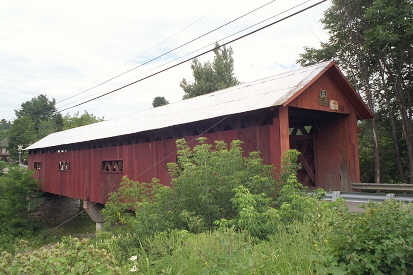
Station Northfield Builder unknown, c1872 Town Lattice, 137′, spanning Dog River on Cox Brook Road, off Route 12 in Northfield Falls.

Read more
coveredbridge 

Second Northfield Covered Bridge, Northfield, Vermont

August 20, 2018August 21, 2018 Vermont2 4996 Views Brook Road, Cox Brook, Second

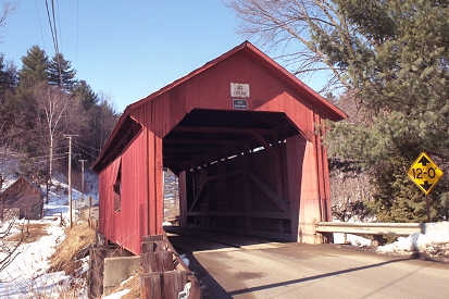
Second Northfield (a/k/a Newell, Lower Cox Brook) Builder unknown, c1872 Queenpost, 56′, spanning Cox Brook on Cox Brook Road, west of

Read more
coveredbridge 

Moseley Covered Bridge, Northfield, Vermont

August 20, 2018August 21, 2018 Vermont2 8315 Views Brook Road, John Moseley, Moseley

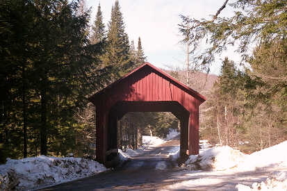
Moseley Northfield John Moseley, 1899 Kingpost, 80′, spanning Stony Brook on Stony Brook Road, approximately a mile west of Route 12A.

Read more

Featured Bridges

Spade Farm Covered Bridge, Ferrisburgh, Vermont
coveredbridge 

Spade Farm Covered Bridge, Ferrisburgh, Vermont

August 19, 2018 Vermont2 0

Spade Farm Ferrisburgh (a/k/a Old Hollow) Privately owned Justin Miller, 1850 Town Lattice, 85′ spanning a farm pond adjacent to US

Longley Covered Bridge, Montgomery, Vermont
coveredbridge 

Longley Covered Bridge, Montgomery, Vermont

August 19, 2018 Vermont2 0
Green River Covered Bridge, Guilford, Vermont
coveredbridge 

Green River Covered Bridge, Guilford, Vermont

August 20, 2018 Vermont2 0
Station Northfield Covered Bridge, Northfield, Vermont
coveredbridge 

Station Northfield Covered Bridge, Northfield, Vermont

August 20, 2018 Vermont2 0

Featured Towns

Granville, Vermont, New England USA
towns 

Granville, Vermont, New England USA

August 15, 2018 Vermont2 0

About Granville, Vermont Addison County Chartered: August 8, 1781 (Vermont Charter) Area: 32,626 Acres = 50.98 Square Miles [ Size

Buels Gore, Vermont, New England USA
towns 

Buels Gore, Vermont, New England USA

August 16, 2018 Vermont2 0
Bennington, Vermont, New England USA
towns 

Bennington, Vermont, New England USA

August 16, 2018 Vermont2 0
Stannard, Vermont, New England USA
towns 

Stannard, Vermont, New England USA

August 14, 2018 Vermont2 0

Archives

  • August 2018

Recent Posts

  • Proctorsville, Vermont, New England USA
  • Panton, Vermont, New England USA
  • Windsor-Cornish Covered Bridge, Windsor, Vermont
  • Pomfret, Vermont, New England USA
  • Rank Population, Vermont, New England USA

Pages

  • About Virtual Vermont
  • Biking in Vermont
  • Chambers of Commerce Business Associations
  • Covered Bridges in Vermont
  • Hiking in Vermont
  • Lodging
  • The Great Moose Watch
  • Towns in Vermont
  • Vermont Museums
  • Vermont Newspapers
  • Vermont Weddings

Tags

Arlington Battle of Bennington Bennington Benning Wentworth Benning Wentworth's Berkshire Brook Road Burlington Charlotte Chittenden Connecticut Cornwall Covered Bridges England Enosburgh Ethan Allen Ferdinand Ira Allen Lake Champlain Londonderry Lyndon Massachusetts Montgomery Multiple Kingpost New England New Hampshire Orange County Orleans Queenpost Revolutionary War Richford Rockingham Rutland Rutland County Rutland Town Salisbury Savannard Jewett St. Albans Town Thomas Chittenden Timothy Andrews Town Lattice Vermont Wentworth Windham County Windsor County
Copyright © 2025 Virtual Vermont. All rights reserved.