Virtual Vermont

Virtual Vermont

  • Home
  • Bridges
  • Towns
  • History
  • Lodging
  • Resources
    • Hiking
    • The Great Moose Watch
    • Vermont Museums
    • Vermont Newspapers
    • Biking in Vermont
    • Chambers of Commerce Business Associations
  • About Us

Lyndon

coveredbridge 

Miller’s Run Covered Bridge, Lyndon, Vermont

August 19, 2018August 21, 2018 Vermont2 3356 Views Lyndon, Miller's Run, spanning Miller's

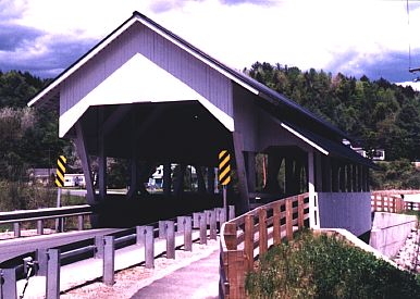
Miller’s Run Lyndon (a/k/a Bradley) E.H. Stone, 1878 Queenpost, 56′, spanning Miller’s Run on Route 122. Restored in 1995, the only

Read more
towns 

Newark, Vermont, New England USA

August 18, 2018August 21, 2018 Vermont2 2522 Views Lyndon, Newark, William Wall

About Newark, Vermont Caledonia County Chartered: August 15, 1781 (Vermont Charter) Area: 23,833 Acres = 37.24 Square Miles [ Size

Read more
towns 

Lyndon, Vermont, New England USA

August 18, 2018August 21, 2018 Vermont2 2081 Views Lyndon, Rhode Island, Town House

About Lyndon, Vermont Caledonia County Chartered: November 20, 1780 (Vermont Charter) Area: 25,404 Acres = 39.69 Square Miles [ Size

Read more

Featured Bridges

Braley Randolph Covered Bridge, Randolph, Vermont
coveredbridge 

Braley Randolph Covered Bridge, Randolph, Vermont

August 14, 2018 Vermont2 0

Braley Randolph (a/k/a Upper Blaisdell, Johnson) Builder unknown, c1904 Multiple Kingpost, 38′ spanning Second Branch White River on Braley Road, just

Salmond Weathersfield Covered Bridge, Weathersfield, Vermont
coveredbridge 

Salmond Weathersfield Covered Bridge, Weathersfield, Vermont

August 20, 2018 Vermont2 0
Green River Covered Bridge, Guilford, Vermont
coveredbridge 

Green River Covered Bridge, Guilford, Vermont

August 20, 2018 Vermont2 0
Chamberlin Covered Bridge, NorthfieldX, Vermont
coveredbridge 

Chamberlin Covered Bridge, NorthfieldX, Vermont

August 20, 2018 Vermont2 0

Featured Towns

Richford, Vermont, New England USA
towns 

Richford, Vermont, New England USA

August 14, 2018 Vermont2 0

About Richford, Vermont Franklin County Chartered: August 21, 1780 (Vermont Charter) Area: 27,673 Acres = 43.24 Square Miles [ Size Rank: 84*

Ferrisburgh, Vermont, New England USA
towns 

Ferrisburgh, Vermont, New England USA

August 18, 2018 Vermont2 0
Wheelock, Vermont, New England USA
towns 

Wheelock, Vermont, New England USA

August 19, 2018 Vermont2 0
Enosburgh, Vermont, New England USA
towns 

Enosburgh, Vermont, New England USA

August 18, 2018 Vermont2 0

Archives

  • August 2018

Recent Posts

  • Proctorsville, Vermont, New England USA
  • Panton, Vermont, New England USA
  • Windsor-Cornish Covered Bridge, Windsor, Vermont
  • Pomfret, Vermont, New England USA
  • Rank Population, Vermont, New England USA

Pages

  • About Virtual Vermont
  • Biking in Vermont
  • Chambers of Commerce Business Associations
  • Covered Bridges in Vermont
  • Hiking in Vermont
  • Lodging
  • The Great Moose Watch
  • Towns in Vermont
  • Vermont Museums
  • Vermont Newspapers
  • Vermont Weddings

Tags

Arlington Battle of Bennington Bennington Benning Wentworth Benning Wentworth's Berkshire Brook Road Burlington Charlotte Chittenden Connecticut Cornwall Covered Bridges England Enosburgh Ethan Allen Ferdinand Ira Allen Lake Champlain Londonderry Lyndon Massachusetts Montgomery Multiple Kingpost New England New Hampshire Orange County Orleans Queenpost Revolutionary War Richford Rockingham Rutland Rutland County Rutland Town Salisbury Savannard Jewett St. Albans Town Thomas Chittenden Timothy Andrews Town Lattice Vermont Wentworth Windham County Windsor County
Copyright © 2021 Virtual Vermont. All rights reserved.