Virtual Vermont

Virtual Vermont

  • Home
  • Bridges
  • Towns
  • History
  • Lodging
  • Resources
    • Hiking
    • The Great Moose Watch
    • Vermont Museums
    • Vermont Newspapers
    • Biking in Vermont
    • Chambers of Commerce Business Associations
  • About Us

Arlington

coveredbridge 

West Arlington Covered Bridge, Arlington, Vermont

August 19, 2018August 21, 2018 Vermont2 4183 Views Arlington, Covered Bridge Road, West Arlington

West Arlington Arlington (a/k/a Bridge at The Green, Arlington Green) Builder unknown, 1852 Town Lattice, 80′, spanning Batten Kill on Covered

Read more
towns 

Sunderland, Vermont, New England USA

August 19, 2018August 21, 2018 Vermont2 5828 Views Arlington, Sunderland, Union Church

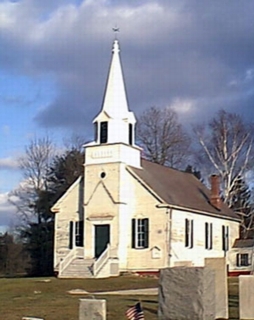
About Sunderland, Vermont Bennington County Chartered: June 29, 1761 (New Hampshire Grant) Area: 29,152 Acres = 45.55 Square Miles [

Read more
towns 

Arlington, Vermont, New England USA

August 16, 2018August 21, 2018 Vermont2 5080 Views Arlington, New York patents, Revolutionary War

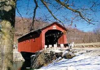
About Arlington, Vermont Bennington County Chartered: July 28, 1761 (New Hampshire Grant) Area: 27,028 Acres = 42.23 Square Miles [

Read more

Featured Bridges

Rutland Railroad Covered Bridge, Shoreham, Vermont
coveredbridge 

Rutland Railroad Covered Bridge, Shoreham, Vermont

August 19, 2018 Vermont2 0

Rutland Railroad Shoreham Rutland Railroad, 1897 Howe Truss, 108′, spanning Lemon Fair River on East Shoreham Road, off Route 22A. Tracks

Station Cornwall Covered Bridge, Cornwall, Vermont
coveredbridge 

Station Cornwall Covered Bridge, Cornwall, Vermont

August 19, 2018 Vermont2 0
Orne Covered Bridge, Irasburg, Vermont
coveredbridge 

Orne Covered Bridge, Irasburg, Vermont

August 20, 2018 Vermont2 0
Hopkins Covered Bridge, Enosburgh, Vermont
coveredbridge 

Hopkins Covered Bridge, Enosburgh, Vermont

August 19, 2018 Vermont2 0

Featured Towns

Enosburgh, Vermont, New England USA
towns 

Enosburgh, Vermont, New England USA

August 18, 2018 Vermont2 0

About Enosburgh, Vermont Franklin County Chartered: May 15, 1780 (Vermont Charter) Area: 30,926 Acres = 48.32 Square Miles [ Size

Cabot, Vermont, New England USA
towns 

Cabot, Vermont, New England USA

August 15, 2018 Vermont2 0
Wilmington, Vermont, New England USA
towns 

Wilmington, Vermont, New England USA

August 19, 2018 Vermont2 0
Pittsfield, Vermont, New England USA
towns 

Pittsfield, Vermont, New England USA

August 14, 2018 Vermont2 0

Archives

  • August 2018

Recent Posts

  • Proctorsville, Vermont, New England USA
  • Panton, Vermont, New England USA
  • Windsor-Cornish Covered Bridge, Windsor, Vermont
  • Pomfret, Vermont, New England USA
  • Rank Population, Vermont, New England USA

Pages

  • About Virtual Vermont
  • Biking in Vermont
  • Chambers of Commerce Business Associations
  • Covered Bridges in Vermont
  • Hiking in Vermont
  • Lodging
  • The Great Moose Watch
  • Towns in Vermont
  • Vermont Museums
  • Vermont Newspapers
  • Vermont Weddings

Tags

Arlington Battle of Bennington Bennington Benning Wentworth Benning Wentworth's Berkshire Brook Road Burlington Charlotte Chittenden Connecticut Cornwall Covered Bridges England Enosburgh Ethan Allen Ferdinand Ira Allen Lake Champlain Londonderry Lyndon Massachusetts Montgomery Multiple Kingpost New England New Hampshire Orange County Orleans Queenpost Revolutionary War Richford Rockingham Rutland Rutland County Rutland Town Salisbury Savannard Jewett St. Albans Town Thomas Chittenden Timothy Andrews Town Lattice Vermont Wentworth Windham County Windsor County
Copyright © 2022 Virtual Vermont. All rights reserved.