Worcester, Vermont, New England USA
About Worcester, Vermont
Washington County
Chartered: June 8, 1763 (New Hampshire Grant)
Area: 24,785 Acres = 38.73 Square Miles [ Size Rank: 148* ]
Coordinates (Geographic Center): N 44° 22′ W 72°33′
Altitude: 780 feet ASL
Population (US Census, 2010): 998 [ Population Rank: 170* ]
Population Density (persons per square mile): 25.8 [ Density Rank: 174* ]
Full Census Info: Town County State
*Area, Population and Density rankings refer to Worcester’s relative position among Vermont’s 255 civic entities (9 cities, 242 towns, 4 gores and grants). Complete rankings are here.
There is a story occasionally circulated that says Benning Wentworth named this town to remind George III that Worcester in England was where Cromwell and his Parliamentarian army had routed Charles II in 1651. It is a mystery why anyone would think George cared, and even more so that Wentworth would have wanted to irk the King in any way, in that George was somewhat miffed at Wentworth to begin with. It is much more likely to have been named for Worcester, Massachusetts, already a century old when this Grants town was named.
Either way, the place apparently wasn’t a bargain, and the grantees must have had a hard time selling it off: it was almost 1800 before anyone settled there. The 1810 Census showed only 41 people, and the Summer of 1816 drove off what few there were. When people did begin to dribble back, the Legislature made some difficulty over the charter having lapsed. Apparently nobody else wanted the place, because the earlier residents eventually turned up as officials of the reorganized town. In the meantime the town’s first records had been destroyed, so the early history was entirely lost.
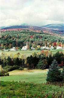
Worcester has some half-dozen peaks of over 3,000 feet perhaps the best known of which is Hunger Mountain, so named by a party of early 19th century deer hunters caught in the woods at nightfall with only a solitary partridge to show for a day’s hunting. When they got home the next day, they said they had been to Mount Hunger. Mount Worcester, though not as high as Hunger, is even more wild and desolate: a plane which crashed on the mountain wasn’t found until a group of hikers stumbled upon it years later.
Activities & Points of Interest
Goings-on in and near Worcester
Calendar of Events provided by the Vermont Department of Tourism & Marketing.
Contact Info
Emergency Services (Statewide): 911
Hospital: Central Vermont Medical Center (Berlin) 802-229-9121
Town Clerk: Sandra Ferver PO Box 161 Worcster, VT 05682
802-223-6942
M T Th 9-3; W 9-5
Churches, Ministries, Charitables
Community : Worcester Community Kitchen & Food Shelf: Lunch served every Wednesday at Worcester Town Hall 11 – noon. Free, no reservations needed. 802-223-2848
United Methodist : Worcester UMC 802-223-5911
Schools
Washington Central Supervisory Union 802-229-0553
Doty Memorial School 802-223-5656
Neighboring Towns
This is a basic geographic reference, intended to show relative location of adjacent towns. Directional accuracy is limited to 16 compass points. There isn’t even the slightest suggestion that one can necessarily travel directly from one town to the next (as in “You can’t get there from here”).
Worcester
Utilities
Notes about utilities:
- One electric or phone company indicates that company serves the entire town. More than one of either indicates each serves different areas of town.
- A listed cable company MIGHT mean the entire town is covered, but not necessarily. More than one listed indicates each serves different areas of town.
- Unless your area is one served by Vermont’s only gas utility, your only option is bottled gas (any dealer).
Cable Comcast 800-266-2278
Electric Green Mountain Power 888-835-4672
Electric Washington Electric Co-op 800-932-5245
Telephone Fairpoint 866-984-2001
