Weston, Vermont, New England USA
About Weston, Vermont
Windsor County
Chartered: October 26, 1799 (Vermont Act of Incorporation)
Area: 22,760 Acres = 35.56 Square Miles [ Size Rank: 179* ]
Coordinates (Geographic Center): N 43° 17′ W 72°47′
Altitude: 1,300 feet ASL
Population (US Census, 2010): 566 [ Population Rank: 201* ]
Population Density (persons per square mile): 15.9 [ Density Rank: 201* ]
Full Census Info: Town County State
*Area, Population and Density rankings refer to Weston’s relative position among Vermont’s 255 civic entities (9 cities, 242 towns, 4 gores and grants). Complete rankings are here.
The present town of Weston was originally part of Andover, but the ridge created by Markham and Terrible Mountains made it impossible to get from one side of town to the other. When the Legislature created the new town, its name was obvious: that part of Andover had always been known as West Town.
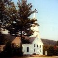
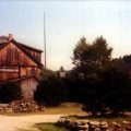
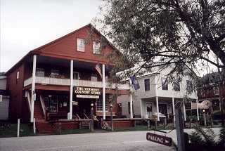
The chief village is picturesque Weston, complete with bandstand on the village green. It is home to a number of shops, including the famous Vermont Country Store. There is a smaller hamlet in the southern tip of the town which has always been known as The Island: a settlement grew where a canal was cut across a bend in the West River to power a mill.
The West River rises in the north and flows southeast to join the Connecticut River at Brattleboro. There are still some maps which use the original Abenaki name Wantastiquet (“at the head” or “source of the river”), an appropriate name: in its 40-mile course it drops over 2,000 feet while draining some 430 square miles.
Activities & Points of Interest
Goings-on in and near Weston
Calendar of Events provided by the Vermont Department of Tourism & Marketing.
Contact Info
Emergency Services (Statewide): 911
Hospital: Rutland Regional Medical Center (Rutland) 802-775-7111
Town Clerk: Jean DeCell PO Box 98 Weston, VT 05161
802-824-6645
M-F 8-1
Churches, Ministries, Charitables
United Methodist : Old Parish Church 802-875-3838
Neighboring Towns
This is a basic geographic reference, intended to show relative location of adjacent towns. Directional accuracy is limited to 16 compass points. There isn’t even the slightest suggestion that one can necessarily travel directly from one town to the next (as in “You can’t get there from here”).
Weston
Utilities
Notes about utilities:
- One electric or phone company indicates that company serves the entire town. More than one of either indicates each serves different areas of town.
- A listed cable company MIGHT mean the entire town is covered, but not necessarily. More than one listed indicates each serves different areas of town.
- Unless your area is one served by Vermont’s only gas utility, your only option is bottled gas (any dealer).
Cable Comcast 800-266-2278
Electric Green Mountain Power 888-835-4672
Telephone Fairpoint 866-984-2001