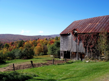
Waterville, Vermont, New England USA
About Waterville, Vermont
Lamoille County
Chartered: November 15, 1824 (Vermont Act of Incorporation)
Area: 10,120 Acres = 15.81 Square Miles [ Size Rank: 235* ]
Coordinates (Geographic Center): N 44° 42′ W 72°46′
Altitude: 394 feet ASL
Population (US Census, 2010): 673 [ Population Rank: 195* ]
Population Density (persons per square mile): 42.6 [ Density Rank: 97* ]
Full Census Info: Town County State
*Area, Population and Density rankings refer to Waterville’s relative position among Vermont’s 255 civic entities (9 cities, 242 towns, 4 gores and grants). Complete rankings are here.
Waterville was created out of three parcels: Coits Gore, Belvidere Leg and part of Bakersfield. The town contains a little more than 10,000 acres, being essentially the valley through which the North Branch of the Lamoille River flows. Probably the town was given its name because the river was the most important feature, in the same way that Brookline was named in 1794.
The legislative records give the reason for the establishment of Waterville as a separate town: “It appears to this assembly that it is inconvenient for the inhabitants of the southeast corner of Bakersfield, and that part of Belvidere called the ‘Leg’ to attend town meetings and transact town business in their respective towns, and that Coits Gore ought to be incorporated and form a part of a new town….” The inconvenience was the hills and mountains that effectively blocked communication from east to west, as it has been elsewhere in Vermont, be it within a town, a county or the state as a whole.
The records of the Governor and Council show that Coits Gore was also called Williamsburgh, part of a grant that had been made to Vermont’s second Surveyor General, James Whitelaw, James Savage and William Coit. It was the latter’s first name that inspired the Williamsburgh name. Another part of the grant was first known as St. Andrews Gore, then became Plainfield.
James Savage and William Coit were surveyors who worked with General Whitelaw for the state; and their grant was given to them in lieu of back salary, as were grants to Tom Chittenden, Ira Allen, and some of the other founding fathers of the Vermont republic.
Activities & Points of Interest
Goings-on in and near Waterville
Calendar of Events provided by the Vermont Department of Tourism & Marketing.
Waterville Historic Preservation Board
Sue Wisehart, Chair. Meetings first Monday of each month at the Town Clerk’s office, 6:30pm. 802-644-5838.
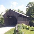
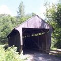
Covered Bridges (With Google Maps and satellite images):
Jaynes Montgomery Village
Click Here for a map of all bridges in Lamoille County.
Contact Info
Emergency Services (Statewide): 911
Hospital: Copley Hospital (Morrisville) 802-888-4231
Town Clerk: Nancy LaRose PO Box 31 Waterville, VT 05492
802-644-8865
M T Th 9-1:30
Churches, Ministries, Charitables
Nazarene : Church of the Nazarene 802-635-2988
United Church of Christ : United Church of Christ
United Methodist : Waterville Union Church 802-644-6670
Schools
Lamoille North Supervisory Union 802-888-3142
Waterville Elementary School 802-644-2242
Neighboring Towns
This is a basic geographic reference, intended to show relative location of adjacent towns. Directional accuracy is limited to 16 compass points. There isn’t even the slightest suggestion that one can necessarily travel directly from one town to the next (as in “You can’t get there from here”).
Waterville
Utilities
Notes about utilities:
- One electric or phone company indicates that company serves the entire town. More than one of either indicates each serves different areas of town.
- A listed cable company MIGHT mean the entire town is covered, but not necessarily. More than one listed indicates each serves different areas of town.
- Unless your area is one served by Vermont’s only gas utility, your only option is bottled gas (any dealer).
Electric Vermont Electric Co-op 800-832-2667
Telephone Fairpoint 866-984-2001