Rockingham, Vermont, New England USA
About Rockingham, Vermont
Windham County
Including: Bellows Falls, Saxtons River
Chartered: December 28, 1752 (New Hampshire Grant)
Area: 26,948 Acres = 42.11 Square Miles [ Size Rank: 96* ]
Coordinates (Geographic Center): N 43° 11′ W 72°29′
Altitude: 320 feet ASL
Population (US Census, 2010): 5,282 [ Population Rank: 23* ]
Population Density (persons per square mile): 125.4 [ Density Rank: 31* ]
Full Census Info: Town County State
*Area, Population and Density rankings refer to Rockingham’s relative position among Vermont’s 255 civic entities (9 cities, 242 towns, 4 gores and grants). Complete rankings are here.
Rockingham is named for Benning Wentworth’s relative, Charles Watson-Wentworth, who succeeded his father as Marquis of Rockingham. Despite a preference for being a country gentleman and sportsman, he felt an obligation to an active role in government: over thirty crucial years, he was twice Prime Minister and held almost every other post of consequence. In this country he is remembered for having secured the repeal of the Stamp Act, and for proposing that the American Colonies be granted their independence.
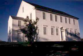
Rockingham village was, at one time, an important place, being centrally located in the town and the site of the town’s offices. As the town grew, more and more businesses chose to locate in Bellows Falls, its location on the Connecticut River providing for easier transportation. With the coming of the railroad through Bellows Falls, the post office at Rockingham closed, and no office has used the town’s name since. This confuses many, thinking that Bellows Falls is a town, when it is actually a village in Rockingham town; confusion is furthered when no village of Rockingham can be found, except for the Meeting House (pictured above) and cemetery marking its former location on the hilltop overlooking Route 103.
Activities & Points of Interest
Goings-on in and near Rockingham
Calendar of Events provided by the Vermont Department of Tourism & Marketing.
Historical Society of Windham County
Old Meeting House
pictured above, built in 1787, used for both public meetings and church services.
Rockingham Meeting House Association
Covered Bridges (With Google Maps and satellite images):
Bartonsville Hall Victorian Village Worral
Click Here for a map of all bridges in Windham County.
Contact Info
Emergency Services (Statewide): 911
Hospital: Rockingham Memorial Hospital (Bellows Falls) 802-463-3903
Town Clerk: Doreen Aldrich PO Box 339 Bellows Falls, VT 05101
802-463-4336
M-F 8:30-4:30
Churches, Ministries, Charitables
United Church of Christ : United Church of Christ
United Church of Christ : United Church of Christ (Saxtons River)
Schools
Windham Northeast Supervisory Union 802-463-9958
Bellows Falls Middle School 802-463-4366
Bellows Falls Union High School 802-463-3944
Central Elementary School 802-463-4346
Cherry Hill Elementary School 802-463-4207
Saxtons River Elementary School 802-869-2637
Neighboring Towns
This is a basic geographic reference, intended to show relative location of adjacent towns. Directional accuracy is limited to 16 compass points. There isn’t even the slightest suggestion that one can necessarily travel directly from one town to the next (as in “You can’t get there from here”).
Rockingham
New Hampshire
Utilities
Notes about utilities:
- One electric or phone company indicates that company serves the entire town. More than one of either indicates each serves different areas of town.
- A listed cable company MIGHT mean the entire town is covered, but not necessarily. More than one listed indicates each serves different areas of town.
- Unless your area is one served by Vermont’s only gas utility, your only option is bottled gas (any dealer).
Cable Comcast 800-266-2278
Electric Green Mountain Power 888-835-4672
Telephone Fairpoint 866-984-2001
Telephone Vermont Telephone Company 800-279-4049


