Wallingford, Vermont, New England USA
About Wallingford, Vermont
Rutland County
Chartered: November 27, 1761 (New Hampshire Grant)
Area: 27,553 Acres = 43.05 Square Miles [ Size Rank: 87* ]
Coordinates (Geographic Center): N 43° 28′ W 72°59′
Altitude: 620 feet ASL
Population (US Census, 2010): 2,079 [ Population Rank: 76* ]
Population Density (persons per square mile): 48.3 [ Density Rank: 83* ]
Full Census Info: Town County State
*Area, Population and Density rankings refer to Wallingford’s relative position among Vermont’s 255 civic entities (9 cities, 242 towns, 4 gores and grants). Complete rankings are here.
Named for Wallingford, Connecticut, the home town of Eliakim Hall, the first named grantee. The principal villages of Wallingford, South Wallingford and East Wallingford all owe much of their early prosperity to the railroads which passed through them.
Wallingford is unusual in Vermont in that almost all of its topographical features have descriptive names, rather than names derived from inviduals (Bear Mountain, White Rock Mountain, Granite Hill, etc.).
According to local lore, Sugar Hill is where maple syrup was first made in Vermont.
Activities & Points of Interest
Goings-on in and near Wallingford
Calendar of Events provided by the Vermont Department of Tourism & Marketing.
Paul Harris House
The brick schoolhouse built by Harris’ grandfather, in which Harris received his early education. Harris grew up to become an attorney and founder of the business organization Rotary International. The Wallingford Rotary holds its meetings here.
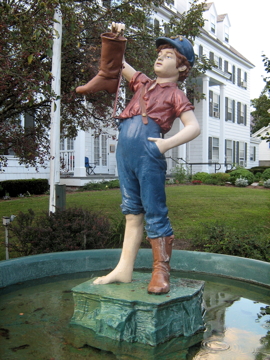
The Boy With The Boot
was a gift to the Town of Wallingford in 1898, in memory of Arnold Hill, by his children. One of his sons, who lived in Chicago, had seen a similar statue there, and the siblings all agreed that such a statue would be a fitting memorial to their late father, who had been the owner of the Wallingford Inn from 1861-1871. It is presumed that damage of some sort (c1910) prompted him being stored away and seemingly forgotten until the Inn’s new owner found him in the attic in 1920. He was restored, and has occupied this same position in front of the Inn ever since (taken indoors during the winter to avoid weather damage). He has become enough of a local icon to have been adopted as the official logo of the town.
Wallingford Historical Society
White Rocks Recreation Area
Picnic areas and hiking trails (part of The Long Trail) to either the top or bottom of the huge rock slide which dominates the eastern face of White Rock Mountain. Even in late summer, the cold air flowing down from the rocks is like entering an air-conditioned room.
Contact Info
Emergency Services (Statewide): 911
Hospital: Rutland Regional Medical Center (Rutland) 802-775-7111
Town Clerk: Joyce Barbieri 75 School Street Wallingford, VT 05773
802-446-2336
M-Th 8-4:30; F 8-12
Churches, Ministries, Charitables
Roman Catholic : St. Patrick
United Methodist : Tinmouth Community Church (United Methodist) 802-446-2633
Schools
Rutland South Supervisory Union 802-775-3246
Wallingford Elementary School 802-446-2141
Neighboring Towns
This is a basic geographic reference, intended to show relative location of adjacent towns. Directional accuracy is limited to 16 compass points. There isn’t even the slightest suggestion that one can necessarily travel directly from one town to the next (as in “You can’t get there from here”).
Wallingford
Utilities
Notes about utilities:
- One electric or phone company indicates that company serves the entire town. More than one of either indicates each serves different areas of town.
- A listed cable company MIGHT mean the entire town is covered, but not necessarily. More than one listed indicates each serves different areas of town.
- Unless your area is one served by Vermont’s only gas utility, your only option is bottled gas (any dealer).
Cable Comcast 800-266-2278
Electric Green Mountain Power 888-835-4672
Telephone Vermont Telephone Company 800-279-4049


