West Windsor, Vermont, New England USA
About West Windsor, Vermont
Windsor County
Chartered: October 26, 1848 (Vermont Act of Incorporation)
Area: 15,894 Acres = 24.83 Square Miles [ Size Rank: 213* ]
Coordinates (Geographic Center): N 43° 29′ W 72°30′
Altitude: 689 feet ASL
Population (US Census, 2010): 1,099 [ Population Rank: 152* ]
Population Density (persons per square mile): 44.3 [ Density Rank: 101* ]
Full Census Info: Town County State
*Area, Population and Density rankings refer to West Windsor’s relative position among Vermont’s 255 civic entities (9 cities, 242 towns, 4 gores and grants). Complete rankings are here.
West Windsor was part of, then separate from, again part of, and again separate from Windsor.
Townspeople must have been interested in dividing the town almost from the time of its first settlement. In 1793, the Legislature created two “parishes” within Windsor, and in 1814 made the parishes separate entities each with representation in the Legislature. Second thoughts prevailed the following year when the two were reunited. The two were again separated in 1848, with West Windsor getting more than half the acreage and about a third of the population.
By the time of the last division the village of West Windsor had been renamed as Brownsville in honor of the families of Briant and John Brown, already heads of large households in West Windsor in the 1791 Census. No settlement has since been known as West Windsor.
Activities & Points of Interest
Goings-on in and near West Windsor
Calendar of Events provided by the Vermont Department of Tourism & Marketing.
West Windsor Historical Society
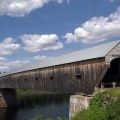
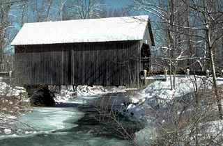
Covered Bridges (With Google Maps and satellite images):
Bests Bowers
Click Here for a map of all bridges in Windsor County.
Contact Info
Emergency Services (Statewide): 911
Hospital: Mount Ascutney Hospital & Health Center (Windsor) 802-674-6711
Town Clerk: Cathy Archibald PO Box 6 Brownsville, VT 05037
802-484-7212
M-F 9-12 and 1:30-4:30
Neighboring Towns
This is a basic geographic reference, intended to show relative location of adjacent towns. Directional accuracy is limited to 16 compass points. There isn’t even the slightest suggestion that one can necessarily travel directly from one town to the next (as in “You can’t get there from here”).
West Windsor
Utilities
Notes about utilities:
- One electric or phone company indicates that company serves the entire town. More than one of either indicates each serves different areas of town.
- A listed cable company MIGHT mean the entire town is covered, but not necessarily. More than one listed indicates each serves different areas of town.
- Unless your area is one served by Vermont’s only gas utility, your only option is bottled gas (any dealer).
Electric Green Mountain Power 888-835-4672
Telephone Fairpoint 866-984-2001
Telephone Vermont Telephone Company 800-279-4049