Danville, Vermont, New England USA
About Danville, Vermont
Caledonia County
Chartered: October 31, 1786 (Vermont Charter)
Area: 39,051 Acres = 61.02 Square Miles [ Size Rank: 9* ]
Coordinates (Geographic Center): N 44° 25′ W 72°08′
Altitude: 1,341 feet ASL
Population (US Census, 2010): 2,196 [ Population Rank: 78* ]
Population Density (persons per square mile): 36 [ Density Rank: 118* ]
Full Census Info: Town County State
*Area, Population and Density rankings refer to Danville’s relative position among Vermont’s 255 civic entities (9 cities, 242 towns, 4 gores and grants). Complete rankings are here.
Considerable mythology exists about the naming of Danville. The story most often repeated (started in Hemenway’s Gazetteerand picked up by various writers and even some recent guidebooks) links it to “a distinguished French Admiral D’Anville”, except that no such person existed. The Reverend Mr. Goodwillie says it is for a son of Jonathan Arnold (founder of St. Johnsbury), which son also did not exist. Other writers have ascribed it to various other Frenchmen.
In fact, the name was suggested by a friend of Ethan Allen’s, Michel Guillaume St. Jean de Crèvecouer, to honor another Frenchman, Jean Baptiste Bourguignon d’Anville, who had been France’s royal cartographer for more than 60 years, and who is considered to have singlehandedly done more to change mapmaking than any man who ever lived. Correspondence between Allen and de Crèvecouer about names for Vermont towns is a matter of record. Under the pseudonym J. Hector St. John, de Crèvecouer wrote one of the best known titles in early Americana, Letters From an American Farmer (1782). It is for de Crèvecouer that St. Johnsbury was named.
Activities & Points of Interest
Goings-on in and near Danville
Calendar of Events provided by the Vermont Department of Tourism & Marketing.
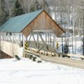
Covered Bridge (With Google Maps and satellite images):
Greenbanks Hollow
Click Here for a map of all bridges in Caledonia County.
Contact Info
Emergency Services (Statewide): 911
Hospital: Northeastern Vermont Regional Hospital (St. Johnsbury) 802-748-8141
Town Clerk: Wendy Somers PO Box 183 Danville, VT 05828
802-684-3352
M-F 8-4
Churches, Ministries, Charitables
Roman Catholic : Our Lady Queen of Peace
United Church of Christ : Danville Congregational 802-684-2176
United Methodist : Danville United Methodist Church 802-684-3389
United Methodist : Walden UMC (West Danville) 802-684-1201
United Methodist : West Danville UMC (West Danville) 802-684-1201
Schools
Caledonia Central Supervisory Union 802-684-3801
Danville School 802-684-3651
Neighboring Towns
This is a basic geographic reference, intended to show relative location of adjacent towns. Directional accuracy is limited to 16 compass points. There isn’t even the slightest suggestion that one can necessarily travel directly from one town to the next (as in “You can’t get there from here”).
Danville
Utilities
Notes about utilities:
- One electric or phone company indicates that company serves the entire town. More than one of either indicates each serves different areas of town.
- A listed cable company MIGHT mean the entire town is covered, but not necessarily. More than one listed indicates each serves different areas of town.
- Unless your area is one served by Vermont’s only gas utility, your only option is bottled gas (any dealer).
Electric Green Mountain Power 888-835-4672
Electric Vermont Electric Co-op 800-832-2667
Electric Washington Electric Co-op 800-932-5245
Telephone Fairpoint 866-984-2001
Telephone Fairpoint 866-984-2001