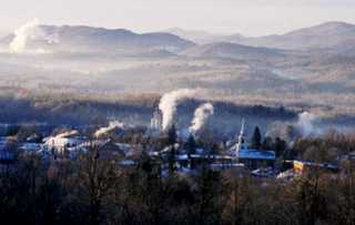
Brandon, Vermont, New England USA
About Brandon, Vermont
Chartered: October 20, 1761 (New Hampshire Grant)
Area: 25,570 Acres = 39.95 Square Miles [ Size Rank: 120* ]
Coordinates (Geographic Center): N 44° 48′ W 72°43′
Altitude: 421 feet ASL
Population (US Census, 2010): 3,966 [ Population Rank: 38* ]
Population Density (persons per square mile): 99.3 [ Density Rank: 41* ]
Full Census Info: Town County State
*Area, Population and Density rankings refer to Brandon’s relative position among Vermont’s 255 civic entities (9 cities, 242 towns, 4 gores and grants). Complete rankings are here.
Brandon was originally chartered as Neshobe, after the birthplace of Captain Josiah Powers (first grantee listed among six members of the family), a section of Littleton, Massachusetts named for a tribe of Natives who lived near the ponds there. As it happens, the Algonquian word, meaning “full of water” or “between water” applies somewhat to this locale as well, with the Otter Creek and Neshobe River flowing through town, and several streams and ponds.
Early settlers apparently disliked the name and asked for it to be changed; the Legislature granted the request in 1784. As for the origin of its present name, Natives had burned the village during a 1777 raid, leading to the nickname “Burnt Town”, gradually evolving into “Brandon”. No substantiation has been presented to support that story; as well, there are a number of place names in England and Ireland consisting of or containing the word Brandon, any of which could have been the source.
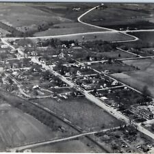
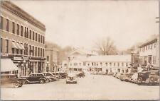
Brandon is roughly midway between Middlebury and Rutland on US Route 7. A pleasant break in the trip, with stately old homes along broad avenues and a traditional village green.
Stephen A. Douglas was born in Brandon. Thomas Davenport was living in the village of Forest Dale when he patented the electric motor he had invented. James Conant manufactured the first stoves made in Vermont here: cast of iron which had been mined in the town, the “Conant Furnace” is now rare and a collector’s piece.
Activities & Points of Interest
Goings-on in and near Brandon
Calendar of Events provided by the Vermont Department of Tourism & Marketing.
Covered Bridge (With Google Maps and satellite images):
Sanderson
Click Here for a map of all bridges in Rutland County.
Contact Info
Emergency Services (Statewide): 911
Police (non-emergency): 802-247-0222
Hospital: Porter Medical Center (Middlebury) 802-388-7901
Town Clerk: William”Bill” Dick 49 Center Street Brandon, VT 05733
802-247-5721
M-F 8:30-4
Churches, Ministries, Charitables
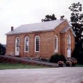
Episcopal : Grace Church (Forest Dale) 802-247-6759
Episcopal : St. Thomas 802-247-6759
Roman Catholic : St. Mary
United Church of Christ : United Church of Christ
United Methodist : Brandon UMC 802-247-6524
Wesleyan : Forest Dale Wesleyan Church (Forest Dale) 802-247-6748
Schools
Rutland Northeast Supervisory Union 802-247-5757
Neshobe School 802-247-3721
Otter Valley Experiential High School 802-247-4162
Otter Valley Union High School 802-247-6833
Neighboring Towns
This is a basic geographic reference, intended to show relative location of adjacent towns. Directional accuracy is limited to 16 compass points. There isn’t even the slightest suggestion that one can necessarily travel directly from one town to the next (as in “You can’t get there from here”).
Brandon
Utilities
Notes about utilities:
- One electric or phone company indicates that company serves the entire town. More than one of either indicates each serves different areas of town.
- A listed cable company MIGHT mean the entire town is covered, but not necessarily. More than one listed indicates each serves different areas of town.
- Unless your area is one served by Vermont’s only gas utility, your only option is bottled gas (any dealer).
Cable Comcast 800-266-2278
Electric Green Mountain Power 888-835-4672
Telephone Fairpoint 866-984-2001